Ibadan
Ibadan (, ; Ìbàdàn) is the capital and most populous city of Oyo State, in Nigeria. It is the third-largest city by population in Nigeria after Lagos and Kano, with a total population of 3,649,000 as of 2021, and over 6 million people within its metropolitan area. It is the country's largest city by geographical area. At the time of Nigeria's independence in 1960, Ibadan was the largest and most populous city in the country, and the second most populous in Africa behind Cairo. Ibadan is ranked the second fastest growing city on the African continent according to the UN Human settlements research program (2022), It is also ranked third in West Africa in the tech startups index. Ibadan joined the UNESCO Global Network of Learning Cities in 2016.
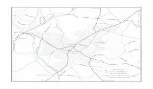
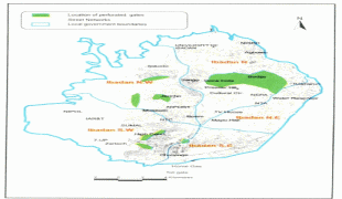
Ibadan is located in south-western Nigeria, 128 km inland northeast of Lagos and 530 km southwest of Abuja, the federal capital. It is a prominent transit point between the coastal region and areas in the hinterland of the country. Ibadan had been the administrative centre of the old Western Region since the early days of British colonial rule, and parts of the city's ancient protective walls still stand to this day. The principal inhabitants of the city are the Yoruba people, as well as various communities (notably Igbo, Hausa, Edo, and Ibibio) from other parts of the country.
Ibadan, coined from the phrase "Eba Odan", which literally means 'by the edge of the meadow', came into existence in 1829, during a period of turmoil that characterized Yorubaland at the time. It was in this period that many old Yoruba cities such as old Oyo (Oyo ile), Ijaye and Owu disappeared, and newer ones such as Abeokuta, new Oyo (Oyo atiba) and Ibadan sprang up to replace them. According to local historians, Lagelu founded the city, and was initially intended to be a war camp for warriors coming from Oyo, Ife and Ijebu. As a forest site containing several ranges of hills, varying in elevation from 160 to 275 metres, the location of the camp offered strategic defence opportunities. Moreover, its location at the fringe of the forest (from which the city got its name) promoted its emergence as a marketing centre for traders and goods from both the forest and grassland areas. In 1852, the Church Missionary Society sent David and Anna Hinderer to found a mission. They decided to build the mission and a church in Ibadan when they arrived in 1853.
Ibadan thus had initially begun as a military state and remained so until the last decade of the 19th century. The city-state also succeeded in building a large empire from the 1860s to the 1890s which extended over much of northern and eastern Yorubaland. It was appropriately nicknamed idi Ibon or “gun base”, because of its unique military character.
In Ibadan, unlike other Yoruba cities with traditional kingship institutions, the warrior class became the rulers of the city as well as the most important economic group.
Ibadan grew into an impressive and sprawling urban center, such that by the end of 1829 Ibadan dominated the Yorùbá region militarily, politically and economically. The military sanctuary expanded even further when refugees began arriving in large numbers from northern Oyo following raids by Fulani warriors. After losing the northern portion of their region to the marauding Fulanis, many Oyo indigenes retreated deeper into the Ibadan environs. The Fulani Caliphate attempted to expand further into the southern region of modern-day Nigeria, but was decisively defeated by the armies of Ibadan in 1840, which eventually halted their progress. The colonial period reinforced the position of the city in the Yoruba urban network. After a small boom in rubber business (1901-1913), cocoa became the main produce of the region and attracted European and Levantine firms, as well as southern and northern traders from Lagos, Ijebu-Ode and Kano among others. The city became a major point of bulk trade. Its central location and accessibility from the capital city of Lagos were major considerations in the choice of Ibadan as the headquarters of the Western Provinces (1939) which ranged from the northernmost areas of Oyo State to Ekeremor, Bomadi and Patani, which were regions transferred from the old Delta province in the Old Western region and later Mid-west to the old Rivers state and later Bayelsa, in the redistricting of Nigeria carried out by the Yakubu Gowon administration shortly before the Nigerian civil war.
Map - Ibadan
Map


Country - Nigeria
 |
 |
| Flag of Nigeria | |
Nigeria has been home to several indigenous pre-colonial states and kingdoms since the second millennium BC, with the Nok civilization in the 15th century BC, marking the first internal unification in the country. The modern state originated with British colonialization in the 19th century, taking its present territorial shape with the merging of the Southern Nigeria Protectorate and Northern Nigeria Protectorate in 1914 by Lord Lugard. The British set up administrative and legal structures while practising indirect rule through traditional chiefdoms in the Nigeria region. Nigeria became a formally independent federation on 1 October 1960. It experienced a civil war from 1967 to 1970, followed by a succession of military dictatorships and democratically elected civilian governments until achieving a stable democracy in the 1999 presidential election. The 2015 general election was the first time an incumbent president failed to be re-elected.
Currency / Language
| ISO | Currency | Symbol | Significant figures |
|---|---|---|---|
| NGN | Nigerian naira | ₦ | 2 |
| ISO | Language |
|---|---|
| EN | English language |
| HA | Hausa language |
| IG | Igbo language |
| YO | Yoruba language |